| Contributors | Affiliation | Role |
|---|---|---|
| Buckley, Larry J. | University of Rhode Island (URI-GSO) | Principal Investigator |
| Caldarone, Elaine | Northeast Fisheries Science Center - Narragansett (NOAA NEFSC) | Co-Principal Investigator |
| Kinkade, Danie | Woods Hole Oceanographic Institution (WHOI BCO-DMO) | BCO-DMO Data Manager |
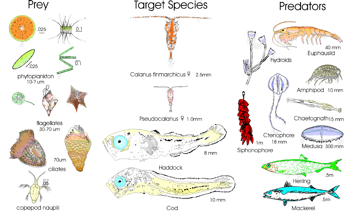
Principle objectives of the US GLOBEC Georges Bank Program were to study the composition of the larval fish community on Georges Bank, to define larval fish distribution across the Bank and within the water column, to determine those factors which influence their vertical distribution, and to determine bank-wide versus "Patch-Study" mortality and growth rates. Emphasis is on Atlantic cod (Gadus morhua) and haddock (Melanogrammus aeglefinus) larvae along with their predators and prey. This study also includes larval distribution and abudance, analysis of feeding habits, and age and growth determination. These objectives were implemented through the use of bongo nets and MOCNESS tows to make the animal collections.
GLOBEC Fish Larvae were collected by Bongo nets. In some cruises nets were equiped with digital flow meters suspended in the mouth of the net and conductivity/temperature/depth measuring packages attached above the bongo.
BCO-DMO Processing Notes:
- Because the original file: “Buckley data for Georges Back GLOBEC website 8-6-2012.xls” contained both Bongo and MOCNESS data, it was subsequently split into three separate data files based on gear and cruise type. These datasets are served separately:
Additional edits to this dataset, fishlarvae_Bon_bss:
-Stations with redundant entries were compared to the eventlog for the cruise and, where needed, lat/lon values were edited to a consistent precision for all positions taken at the same date/time.
- Two stations (6 and 36.5) in deployment EN282 in fishlarvae_Bon_bss contained identical information for station lat/lon, time, depth, avg sal, etc. but different day and yrday. When validated against other files' station information at the same location, time, etc. the day and yrday were corrected (fishlarvaeB and the eventlog for EN282 were used to validate):
Station 6: day 12, yrday0 102 was edited day 11, yrday0 101
Station 36.5: day 19, yrday0 109 was edited to day 18, yrday0 108
- Edited precision for sal_avg, temp_avg, sigma_t_avg to three decimals.
- Edited values of 99 for sal_avg, temp_avg, sigma_t_avg to "nd".
- Parameter names were edited to adhere to BCO-DMO and GLOBEC convention, of particular note:
| File |
|---|
fishlarvae_Bon_bss.csv (Comma Separated Values (.csv), 172.38 KB) MD5:9ee01bbbeaacd54887e13e472694db87 Primary data file for dataset ID 3721 |
| Parameter | Description | Units |
| cruise_id | Cruise Id, e.g., AL9306 represents the R/V Albatross cruise 9306 | dimensionless |
| year | Four digit year. | |
| brief_desc | Brief description, open-ended and specific to dataset. | dimensionless |
| station | Station number, submitted by PI as tow. | dimensionless |
| lat | Latitude in decimal degrees. | decimal degrees |
| lon | Longitude in decimal degrees where negative values denote Westerly postitions. | decimal degrees |
| day_local | Day of month in local time. | dimensionless |
| month_local | Month of year in local time. | dimensionless |
| time_local | Local time of observation or tow, originally reported as EDST (Eastern Daylight Savings Time). | hhmm |
| length_day | Number of hours between civil sunrise and civil sunset, originally reported as day_length. | decimal hours |
| temp_avg | Average temperature, as observed by a CTD unit, "primary sensor", ITS 68 or 90 scale, reported in degrees C. For BONGO: average of measurements recorded from 60m to surface. | Degrees celsius |
| sal_avg | Average salinity, calculated from the CTD "primary sensors" of conductivity and temperature, Practical Salinity Scale, dimensionless. For BONGO: average of measurements recorded from 60m to surface. | dimensionless |
| sigma_t_avg | Average sigma-t density, in kg/m3 - 1000. For BONGO: average of measurements recorded from 60m to surface. | kg/m^3 - 1000 |
| depth_w | Water depth in meters. | meters |
| depth_tow_max | Maximum depth of a towed instrument. | meters |
| sample | Unique identifier for obtained samples. | dimensionless |
| length | Length of dead larval specimen, originally reported as larva_len. | mm |
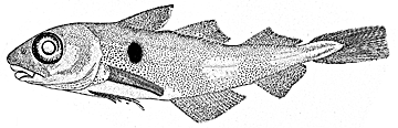
| common_name | Common name of sample, originally reported as species. Cod = Atlantic cod (Gadus morhua) and haddock is Melanogrammus aeglefinus. | dimensionless |
| size_class | Larval size groupings (classes), based on actual or predicted protein content of a larva. If pro <= 50 micrograms then size_class=1. If 50 < pro <= 193 then size_class=2. If 193 < pro <= 1200 then size_class=3. If pro > 1200 then size_class=4. | dimensionless |
| prot_total | Total amount of protein in a larva. | micrograms |
| RNA | Total amount of RNA in a larva. | micrograms |
| DNA | Total amount of DNA in a larva. | micrograms |
| rings | Total number of visible rings on an otolith, beginning at the hatch check or nucleus. | dimensionless |
| sagitta_diam | Total diameter of sagitta otolith as measured with microscope micrometer; originally reported as sag_diam. | microns |
| sagitta_chk_diam | Diameter of sagitta otolith up to the hatch check (nucleus), measured with microscope micrometer; originally reported as sag_chk_diam. | microns |
| lapillus_diam | Total diameter of lapillus otolith, measured with microscope micrometer; originally reported as lap_diam. | microns |
| growth | Instantaneous protein-specific growth rate (G per day) estimated from G = -0.147 + 0.009(avg_temp)+ 0.045(sRD), where sRD is the standardized ratio of RNA to DNA (reported in the data as RNA_DNA). Equation had been validated for cod and haddock larvae with protein content <=1200 micrograms. | G per day |
| RNA_DNA | The ratio of RNA to DNA standardized to a DNA/RNA standard curve slope ratio of 2.43; originally reported as srd. | dimensionless |
| prot_predicted | Predicted total amount of protein in larvae missing protein data. For cod, predicted protein = (20.67*DNA) + 2.91. For haddock, predicted protein = (20.01*DNA) - 3.22. This parameters was originally reported as predict_pro. | micrograms |
| yrday0_local | Day of year at local time, where Jan1 is day zero. | dimensionless |
| Dataset-specific Instrument Name | Bongo Net |
| Generic Instrument Name | Bongo Net |
| Dataset-specific Description | Bongo nets used during this study were simple paired plankton nets, towed double-obliquely through the water column. Net diameter was 61 cm with 333 and 505 micrometer mesh size. Nets used during sampling were not capable of discrete "known-depth" sampling. |
| Generic Instrument Description | A Bongo Net consists of paired plankton nets, typically with a 60 cm diameter mouth opening and varying mesh sizes, 10 to 1000 micron. The Bongo Frame was designed by the National Marine Fisheries Service for use in the MARMAP program. It consists of two cylindrical collars connected with a yoke so that replicate samples are collected at the same time. Variations in models are designed for either vertical hauls (OI-2500 = NMFS Pairovet-Style, MARMAP Bongo, CalVET) or both oblique and vertical hauls (Aquatic Research). The OI-1200 has an opening and closing mechanism that allows discrete "known-depth" sampling. This model is large enough to filter water at the rate of 47.5 m3/minute when towing at a speed of two knots. More information: Ocean Instruments, Aquatic Research, Sea-Gear |
| Dataset-specific Instrument Name | CTD Sea-Bird SEACAT 19 |
| Generic Instrument Name | CTD Sea-Bird SEACAT 19 |
| Dataset-specific Description | The CTD was attached on the wire above the Bongo frame. |
| Generic Instrument Description | The Sea-Bird SBE 19 SEACAT Recorder measures conductivity, temperature, and pressure (depth). The SEACAT is self-powered and self-contained and can be deployed in profiling or moored mode. The SBE 19 SEACAT was replaced in 2001 by the 19plus. more information from Sea-Bird Electronics |
| Website | |
| Platform | R/V Endeavor |
| Start Date | 1995-04-11 |
| End Date | 1995-04-22 |
| Description | broad-scale |
| Website | |
| Platform | R/V Albatross IV |
| Report | |
| Start Date | 1996-05-06 |
| End Date | 1996-05-17 |
| Description | broad-scale |
| Website | |
| Platform | R/V Endeavor |
| Start Date | 1996-04-08 |
| End Date | 1996-04-20 |
| Description | broad-scale |
The U.S. GLOBEC Georges Bank Program is a large multi- disciplinary multi-year oceanographic effort. The proximate goal is to understand the population dynamics of key species on the Bank - Cod, Haddock, and two species of zooplankton (Calanus finmarchicus and Pseudocalanus) - in terms of their coupling to the physical environment and in terms of their predators and prey. The ultimate goal is to be able to predict changes in the distribution and abundance of these species as a result of changes in their physical and biotic environment as well as to anticipate how their populations might respond to climate change.
The effort is substantial, requiring broad-scale surveys of the entire Bank, and process studies which focus both on the links between the target species and their physical environment, and the determination of fundamental aspects of these species' life history (birth rates, growth rates, death rates, etc).
Equally important are the modelling efforts that are ongoing which seek to provide realistic predictions of the flow field and which utilize the life history information to produce an integrated view of the dynamics of the populations.
The U.S. GLOBEC Georges Bank Executive Committee (EXCO) provides program leadership and effective communication with the funding agencies.
U.S. GLOBEC (GLOBal ocean ECosystems dynamics) is a research program organized by oceanographers and fisheries scientists to address the question of how global climate change may affect the abundance and production of animals in the sea.
The U.S. GLOBEC Program currently had major research efforts underway in the Georges Bank / Northwest Atlantic Region, and the Northeast Pacific (with components in the California Current and in the Coastal Gulf of Alaska). U.S. GLOBEC was a major contributor to International GLOBEC efforts in the Southern Ocean and Western Antarctic Peninsula (WAP).
| Funding Source | Award |
|---|---|
| National Science Foundation (NSF) | |
| National Oceanic and Atmospheric Administration (NOAA) |